
Keynote Speakers
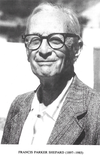
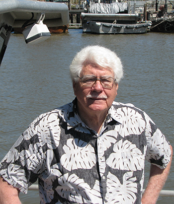
OPENING KEYNOTE: A tribute to Francis Parker Shepard – Father of Marine Geology – Insights of His Work on Submarine Canyons. By H. Gary Greene, MLML-CSU | |
|
| Fran Shepard was a pioneer in the study of Submarine Canyons and marine geology. He was a gentleman geologist interested in marine geology that stemmed from his exposure to the sea through his father’s company, the Shepard Steamship Line, and sailing on his father’s yachts along the east coast of the U.S. He was Professor of Geology at the University of Illinois after graduating from the University of Chicago in 1922 focusing on structural geology, and later became Professor of Marine Geology at Scripps Institution of Oceanography. In his own words he stated “. . . in spite of being at the University of Illinois, a long ways from the ocean, I became the first geologist who took up marine geology as his main scientific interest.” Among his students were Robert Dietz, K.O. Emery, Bruce Martin, and Robert Dill, all who advanced marine geology and the study of submarine canyons. Fran published the first textbook on marine geology and with one of his students, Robert Dill, published a book on Submarine Canyons and Other Sea Valleys. Fran’s work on submarine canyons initiated with a sabbatical he took at Scripps from 1933 to 1934 when he studied submarine canyons in southern California and then branched out to study other world ocean canyons after that. He essentially transferred his knowledge of canyon and valley geomorphology from what he learned on land to the marine environment to describe submarine canyons. He proposed that all submarine canyons were subaerially eroded during the low stands of sea level in the Pleistocene. Later, near the time he retired in 1966 Fran became frustrated with the lack of interest in submarine canyons and the inability to relate canyon morphologies to the new sciences of plate tectonics. My encounters with Fran occurred after his retirement and our mutual interest in the origin of, and processes associated with Monterey Canyon and other submarine canyons along the California coast. The evolution of thought between us in regard to how canyons form on passive, convergent, and transform plate margins will be presented along with humorous antidotes that Fran shared in regard to his career in marine geology. *** Professor Greene obtained a PhD degree in Marine Geology from Stanford University in 1977. He has over 50 years of experience in mapping the geology of the seafloor, which he gained while working in industry as an undergraduate, with the U.S. Geological Survey from 1966 to 1994 and in academia thereafter. From 1994 to 2000 he was Director of Moss Landing Marine Laboratories (MLML) of the California State University system where he taught geological oceanography and established the Center for Habitat Studies. Dr. Greene retired from teaching in 2006 to devote full time to running the Center for Habitat Studies and the newly established Tombolo institute on Orcas Island in Washington State, USA. He now heads the SeaDoc Society Tombolo Mapping Lab, is a research faculty member at Friday Harbor Labs (University of Washington), and Emeritus Professor at MLML. He first became interested in submarine canyons during his tenor with the USGS and while working on a Masters Degree at Moss Landing Marine Labs (San Jose State University) in 1966. His PhD dissertation was on the geology of the Monterey Bay region where he intensely studied Monterey Canyon, relating it to an origin and evolution along a transform plate margin. Since that time he has continued to study submarine canyons along the California margin and elsewhere in the Pacific and has published over a dozen papers on the subject. Dr. Greene is also continuing to do research in marine benthic habitat mapping and geohazards evaluation within submarine canyons. He pioneered deep-water marine benthic habitat mapping in the United States and has contributed to many habitat-mapping efforts globally, including the mapping of submarine canyon heads. |
INCISE Theme 1: Canyon processes in the space-time continuum (formation, evolution, circulation) - "Flow Patterns, Nutrient Fluxes and Biological Aggregation in Submarine Canyons" - Susan Allen, UBC | |
 | Dr. Susan Allen, Professor and Associate Dean at the University of British Columbia, is a physical oceanographer who uses all types of models including scaling, analytics, laboratory and numerical to understand, and predict coastal oceanographic processes and biogeochemical-physical interactions in the ocean. Her longest standing obsession has been the flow over and around topography, particular submarine canyons. The goal is to be able to understand the rotationally dominated flow over topography and quantitatively estimate the cross-bathymetric gradient flows and the scalar fluxes they generate. The SCOR working group on Deep Ocean Exchange with the Shelf invited a review paper, whihc she co-wrote with Xavier Durrieu de Madron. In this paper, they reviewed and synthesized the community's accomplishments in understanding and quantifying flows over canyons. Fluid dynamics forces geostrophic flows along isobaths, limiting exchange between the shallow shelf and the deep ocean. Submarine canyons are important conduits between these two domains. Exchange flows can generated by strong upwelling and downwelling currents, rapidly changing currents and by enhanced mixing due to internal wave trapping and focusing, local internal wave generation or tidal resonance. These enhanced exchange flows can be conduits for nutrients or low oxygen water onto the shelf, or in the other direction, for cascading flows carrying high organic carbon loads to the deep ocean. The dynamics of the flows in the canyons cause small spatial scales and strong vertical flows. The first leads to heterogeneity in habitats and the latter to aggregation of zooplankton or small fish. In this talk, we will discuss flow patterns, nutrient fluxes and biological aggregation giving quantitative estimates where possible. |
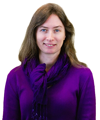
INCISE Theme 2: New ways to study submarine canyons: integrated programs, new technologies and coordinated monitoring efforts - "Obtaining an integrated, multiresolution picture of a single submarine canyon system" - Veerle Huvenne, NOC | |
 | Dr. ir. Veerle Huvenne is based at the National Oceanography Centre, Southampton, UK, where she coordinates the Seafloor and Habitat Mapping Team. She is Principal Investigator on the ERC Starting Grant CODEMAP and has >15 years of experience in habitat mapping and sediment dynamics, mainly focussing on complex deep-sea environments such as submarine canyons, cold-water coral settings, hydrothermal vents and seamounts. She has extensive expertise working with new technologies and marine robotic systems such as AUVs and ROVs (Autonomous Underwater Vehicles and Remotely Operated Vehicles) and often works closely with the engineering teams on the development of new sensor or vehicle capabilities. This presentation will give an overview of the most recent efforts to obtain a holistic understanding of Whittard Canyon, Celtic Margin, NE Atlantic. Whittard Canyon is a large, dendritic, shelf-incising canyon, currently located ca. 200nm from the closest shoreline. During glacial times, when sea level was much lower, the canyon frequently funnelled large catastrophic sediment flows to the deep sea. In recent times, this activity is much reduced, but this does not mean that the canyon is inactive. Integrating all existing knowledge about the canyon from different disciplines (geology, sedimentology, geomorphology, oceanography, ecology and benthic biology; Amaro et al., subm.), we will review the processes currently affecting canyon formation and sediment transport, and discuss their effects on the benthic communities. The second part of this presentation will demonstrate how a combination of the latest developments in marine robotic technology can be used to obtain a complete, multiscale, 3-dimensional image of a submarine canyon and its benthic habitats. Expedition CODEMAP2015 made use of the Autosub6000 AUV, Isis ROV and a Seaglider to apply a nested mapping scheme in Whittard Canyon, including detailed side-ways mapping of vertical and overhanging canyon walls and continuous measurements of the water column structure. |
INCISE Theme 3: Patterns in submarine canyons: role of scale and heterogeneity - Craig Smith, University of Hawai'i, US - "Early phytoplankton bloom and large seafloor productivity footprint in Andvord Bay fjord, Antarctica: results from the first FjordEco cruise" | |
 | Dr. Craig Smith obtained his Ph.D. from Scripp’s Institution of Oceanography in 1983 and is currently a Professor of Oceanography at the University of Hawai’i. He has strong interests in biodiversity, disturbance ecology, and human impacts in seafloor ecosystems. Craig has conducted research in Antarctica, mangroves, submarine canyons, organic-fall communities, cold seeps, continental slopes, and abyssal plains to obtain a broad perspective of natural and stressed marine ecosystems. He has lead over 50 research expeditions from the equator to Antarctica, and has conducted over 100 HOV, ROV and AUV dives. Craig has also published over 140 papers in the scientific literature on seafloor ecology, biodiversity, climate-change impacts, and the design of marine protected areas. Fjords are glacially cut submarine canyons that dissect polar margins. The West Antarctic Peninsula (WAP) has an extensive, rapidly warming system of sub-polar fjords with tidewater glaciers. These fjords appear to be hotspots of biomass and biodiversity, with sustained phytoplankton blooms, massive aggregations of krill and humpback whales, and high abundance and species richness of megabenthos. This spectacular marine life attracts >20,000 tourists to individual WAP fjords each summer. Nonetheless, drivers of high fjord productivity/biodiversity, as well as the sensitivity of WAP fjord ecosystems to climate warming, are very poorly understood. Within the FjordEco Project, we are conducting an integrated field and modeling program to evaluate physical oceanographic processes, glacial inputs, plankton dynamics, and benthic community structure and function in Andvord Bay, a sub-polar WAP fjord, to address two overarching questions: (1) What physical, glaciological, biological and chemical processes interact to enhance fjord productivity and biodiversity? (2) How sensitive are these fjord processes to increased glacial meltwater and sediment inputs expected from climate warming? Our field program will test mechanistic hypotheses concerning oceanographic/glaciological forcing and phytoplankton and benthic community responses, and includes: (1) Deployments of moorings (physical oceanographic, sediment traps, seafloor time-lapse camera), weather stations, and glacial and sea-ice time-lapse cameras to obtain an integrated view of ecosystem processes in the fjord and adjacent Gelarche Strait over 15 months; and (2) spring and fall process cruises using shipboard CTD, towed Acrobat system, AUV glider, and intensive studies of phytoplankton and benthic species composition and production/respiration to elucidate fjord ecosystem structure and function during different seasons. We will then use a coupled physical/biological modeling approach (ROMS/NEMURO) to evaluate drivers of biogeochemical cycles in WAP fjords and to explore their potential sensitivity to enhanced meltwater and sediment inputs. |
INCISE Theme 4: Physical and anthropogenic disturbance in submarine canyons, conservation and marine pollicy - "The Gully Marine Protected Area: reflections on 20 years of conservation efforts for Canada’s largest submarine canyon" - Derek Fenton, BIO-DFO | |
 | Mr. Derek Fenton works with the Marine Protected Areas (MPA) Program of Fisheries and Oceans Canada in Dartmouth, Nova Scotia, Canada. He has 20 years of experience with the identification, establishment and management of protected areas under the Oceans Act, the Fisheries Act and the Canada Wildlife Act. Coming from a fishing family he dedicated his education at Saint Mary’s University and Dalhousie University on marine applications, with particular focus on coastal mapping, public involvement and environmental policy implementation. As part of team at Fisheries and Oceans, he is responsible for the ongoing management of the Gully Marine Protected Area, the Musquash Estuary Marine Protected Area, deep-sea coral and sponge conservation areas and the establishment of new protected areas under the Oceans Act. This involves directing and participating in public outreach, implementation of regulations, management planning, surveillance and enforcement, research planning and evaluating the effectiveness of these areas. The Gully submarine canyon is well-known for its habitat complexity and species diversity. For example, it is a nationally significant as a habitat for cold-water corals and rare cetaceans, such as the endangered population of northern bottlenose whales. Recently, the Gully celebrated its first decade as a Marine Protected Area (MPA) under Canada’s Oceans Act. Since the initial conservation interest in the early 1990s to today, the management of this canyon ecosystem, and the supporting science activities, have evolved. Great strides have been made to understand the canyon ecosystem, to develop and report on ecosystem indicators, and to address key conservation priorities. This talk will introduce the audience to the Gully and its inhabitants, the history and evolution of management and science efforts, and present the key challenges and opportunities of management and research in an offshore setting in eastern Canada. These include ensuring enforcement and compliance with the MPA Regulations; managing research and tourism through an application and evaluation process; developing and implementing an ecosystem monitoring program; engaging the public in education and outreach efforts; and implementing and evaluating a variety of management activities. The talk will conclude with a look ahead to the next decade of canyon management and priorities for research and management. |
Special Keynote session: The challenge of monitoring sediment flows within submarine canyons: lessons learned in Monterey Canyon - Charlie Paull, MBARI | |
 | Dr. Charlie Paull is a Senior Scientist at the Monterey Bay Aquarium Research Institute (MBARI). His career as a Marine Geologist has involved an unusually broad diversity of research topics including gas-hydrates, cold seep vents, canyon processes, neotectonics and submarine landslides. He’s played an integral role in many research projects including being co-chief scientist for ODP Leg 164, developing and installing cable-connected sea floor observing infrastructures, and leading numerous expeditions using ROVs, HOVs, and AUVs. These efforts are documented in over 200 peer-reviewed publications. He is currently leading the Monterey Bay Coordinated Canyon Experiment, a multi-institute, international research program focused on making physical measurements within turbidity flows in-situ. Submarine canyons are conduits in which sediment-laden gravity flows swiftly transport massive amounts of sediment from the shallow ocean to the deep sea. While these flows are among the most important processes by which sediments are carried across the Earth’s surface and are credited for forming the canyons, very few direct measurements have ever been made of what actually happens within these flows during transport events. The lack of empirical data on sediment flows is a consequence of the difficulty in accessing canyon floors, the inability to predict when flows will happen, and the reality that energetic flows put monitoring equipment at risk. Documenting and directly measuring the passage of sediment-laden flows through the axis of a submarine canyon is the goal of a currently ongoing multi-institution program, called the Coordinated Canyon Experiment (CCE). The CCE is coordinated by the Monterey Bay Aquarium Research Institute, with partners and partial support from the National Oceanographic Center and Hull University in the UK, the US Geological Survey, and Ocean University of China. The vision for the CCE is to deploy multiple types of sensors in Monterey Canyon over two winter seasons, extending from October of 2015 to the spring of 2017. This includes an array of six traditional moorings carrying downward looking vertical current velocity profilers and near bottom sediment traps distributed along the axis of the canyon, down to 1,900 m water depth. These are augmented by a series of novel sensors. Among them is a Benthic Instrument Node (BIN) designed to capture the details of the passage of a turbidity flow. The BIN includes four vertical current-velocity profilers of different frequencies running continuously at maximum sampling rates and recording on a common time base, as well as salinity, temperature, and turbidity sensors. A McLane profiler is monitoring the current velocities and temperatures in the benthic boundary layer directly upstream of the BIN. An array of benthic event detectors, (smart boulders that record their own motion) were initially buried within the floor and are designed to record their transport down canyon within a flow. An array of three precision-triangulation beacons was deployed to assess seafloor creep within the sediment fill of the canyon floor. The data series from instruments deployed throughout the canyon will be coupled with repeated high resolution AUV mapping of the canyon floor allowing changes in the canyon floor morphology to be related to the sediment-flow characteristics, as documented in multiple platforms. The CCE is arguably the most comprehensive source-to-sink monitoring of submarine sediment-laden flows that has ever been attempted. While still early in the experiment, two events within the canyon floor have been already recorded. Progress in this on-going experiment and lessons learned to date will be presented. |
Local Organizing Committee (ONC):
Scientific Committee:
INCISE Steering Committee:
-
Veerle Huvene (NOC)
-
Jamie Davies (UPL)
-
Joshu Mountjoy (NIWA)
-
Rob Hall (UEA)
-
Peter Harris (GRID-Arendal)
-
Nathalie Valette-Silver (NOAA)
-
Aaron Micallef (University of Malta)
-
Fabio De Leo (ONC)